

"Offline app for Nepal" usually means one of two very different things depending on who's searching. Sometimes it's a trekker heading into the Annapurna or Everest region wondering what still works with zero bars. Sometimes it's someone searching "Nagarik App" hoping to find Nepal's official government services app. Both are worth addressing directly, so let's do both.
"Nagarik App" versus "Nagarik Nepal": these are different apps
This needs to be said clearly, because the naming overlap is genuinely confusing and we'd rather be upfront about it than let anyone download the wrong thing. "Nagarik App" is the Government of Nepal's official citizen services application, used for things like accessing government records and digital identity services. It's operated by the government, not by us.
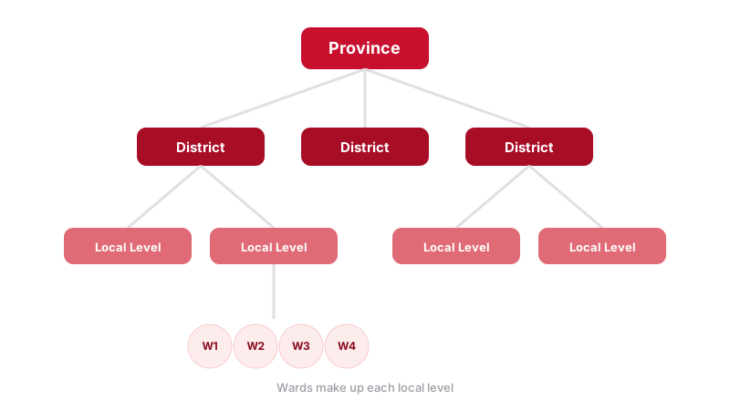
Nagarik Nepal, the app this website is about, is a completely separate, independently built reference app. It doesn't handle government services, ID documents, or anything transactional with the state. What it does is bundle administrative reference data, provinces, districts, local levels, national symbols, alongside a few everyday tools like rashifal and exchange rates, all built to work offline. If you're looking for official government e-services, you want the government's Nagarik App, not this one. If you're looking for a fast, offline reference to Nepal's structure and a bit of culture, that's what we've built.
Offline maps
For actual trail navigation in remote areas, dedicated offline mapping apps that let you download a region in advance remain the standard choice, since they store real topographic and trail data locally. Google Maps also supports downloading specific areas for offline use before you lose signal, which covers basic road navigation reasonably well in more developed areas, though it's noticeably weaker on trekking trails than dedicated offline hiking map tools.
Offline administrative and reference data
This is the category Nagarik Nepal is built for specifically: knowing which district or local level you're in, comparing two provinces, or looking up basic facts about the country without needing a data connection at all. The full app guide covers exactly what's bundled offline versus what needs a connection, but the short version is that everything except rashifal and exchange rates works with zero signal, since those two are the only pieces of data that genuinely change every day.
Nepali calendar and rashifal apps
Hamro Patro is by far the most widely used Nepali calendar and rashifal app, and for good reason: it's comprehensive, well maintained, and the closest thing to a default choice for checking the Bikram Sambat date, tithi and daily rashifal. Worth noting: calendar and horoscope content is inherently daily and connection-dependent, no app can meaningfully bundle "today's rashifal" offline in any useful way, since by definition it changes every day.
Dictionary and translation apps
If you're traveling in Nepal without much Nepali, a downloaded offline dictionary or translation pack is worth setting up before you leave the last reliable Wi-Fi you'll see for a while. Google Translate supports downloading language packs (including Nepali) for offline text translation, though it's noticeably less reliable offline for camera translation or conversation mode, both of which typically want a live connection to run properly. For basic phrasebook-style needs, a downloaded offline dictionary app tends to be more dependable than trying to force a translation app to work without signal.
Staying reachable with patchy signal
Outside the Kathmandu Valley and the larger cities, mobile signal in Nepal can be inconsistent, particularly in Karnali and parts of the far west, and in high-altitude trekking regions where towers are sparse. A few practical habits help more than any specific app: keep messages short and text-based rather than relying on voice or video calls where coverage is marginal, let people know in advance that you may go quiet for a day or two on a trek, and if you're in a genuinely remote area for an extended stretch, a satellite messenger device is a more reliable fallback than hoping a phone app will somehow find signal that isn't there.
What works offline: a quick comparison
| App category | Works with zero signal | Needs a connection |
|---|---|---|
| Pre-downloaded offline maps | Navigation within the downloaded area | Search, live traffic, undownloaded areas |
| Nagarik Nepal | Provinces, districts, local levels, map, quiz, anthem | Rashifal, exchange rates |
| Nepali calendar/rashifal apps | Static calendar conversion logic, if built in | Daily rashifal, live event content |
| Translation apps | Downloaded language pack, text-to-text | Camera translation, conversation mode |
| Government Nagarik App | Little to nothing, it's a services portal | Almost everything, by design |
What to actually check before you go offline
If you're heading somewhere with unreliable signal, whether that's rural Karnali or just a long bus ride through the hills, a quick pre-trip checklist helps:
- Download offline map areas for wherever you're headed, in advance, on Wi-Fi.
- Confirm which reference apps actually work offline versus which just show a loading spinner with no signal. Not every app that claims offline support handles it gracefully.
- Don't rely on daily-updating content, rashifal, news, exchange rates, being available offline. It won't be, by design.
- Download a language pack for translation apps in advance if you're not comfortable in Nepali.
- If you specifically need Nepal's administrative structure (province, district, local level, ward) for research, fieldwork or just curiosity, that's the one category that can be fully bundled offline, which is exactly what Nagarik Nepal does.
Get the offline provinces, districts and local levels reference for Nepal.
Join the Waitlist