

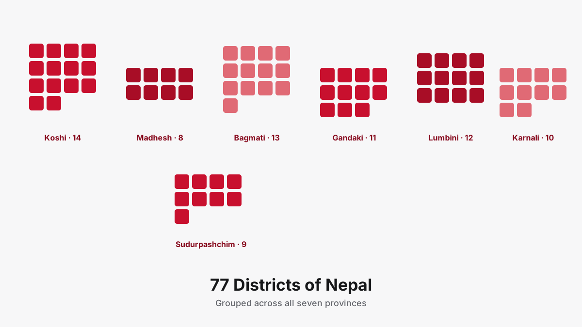
Nepal has 77 districts. That number has stayed fixed since a 2015 boundary adjustment split the former Nawalparasi district into two, and it hasn't moved since, even though the local government structure underneath the districts has changed more than once. Here's the full list, grouped by province, plus what a district actually does today now that provinces and local levels handle most of the governing.
What a district means since 2015
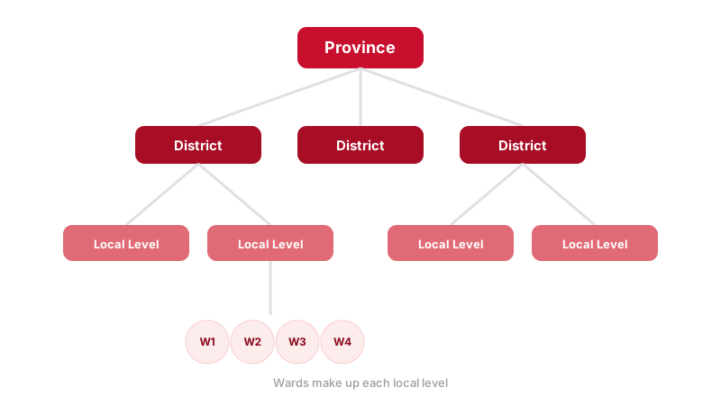
Before Nepal's 2015 constitution, districts were the main unit of local administration, each run by a Chief District Officer with real day-to-day authority. That's changed. Under the current federal structure, the two levels that actually govern, with their own elected representatives and budgets, are the province and the local level (the municipality or rural municipality you actually live in). The district today mostly survives as a geographic and administrative boundary: useful for organizing land records, courts, and security offices, but no longer a separate tier of elected government in its own right.
This is a common point of confusion, including for Nepalis who grew up before the change. If you're filling out a form that asks for your district, it still matters. If you're asking who represents you politically, the answer runs through your local level and province, not your district.
The complete list, by province
Koshi Province (14 districts)
Jhapa, Ilam, Panchthar, Taplejung, Morang, Sunsari, Dhankuta, Terhathum, Sankhuwasabha, Bhojpur, Solukhumbu, Okhaldhunga, Khotang, Udayapur.
Madhesh Province (8 districts)
Saptari, Siraha, Dhanusha, Mahottari, Sarlahi, Bara, Parsa, Rautahat.
Bagmati Province (13 districts)
Sindhuli, Ramechhap, Dolakha, Bhaktapur, Dhading, Kathmandu, Kavrepalanchok, Lalitpur, Nuwakot, Rasuwa, Sindhupalchok, Makwanpur, Chitwan.
Gandaki Province (11 districts)
Baglung, Gorkha, Kaski, Lamjung, Manang, Mustang, Myagdi, Nawalpur, Parbat, Syangja, Tanahun.
Lumbini Province (12 districts)
Kapilvastu, Parasi, Rupandehi, Arghakhanchi, Gulmi, Palpa, Dang, Pyuthan, Rolpa, Eastern Rukum, Banke, Bardiya.
Karnali Province (10 districts)
Dolpa, Humla, Jumla, Kalikot, Mugu, Surkhet, Dailekh, Jajarkot, Western Rukum, Salyan.
Sudurpashchim Province (9 districts)
Bajura, Bajhang, Achham, Doti, Kailali, Kanchanpur, Dadeldhura, Baitadi, Darchula.
That's 14 + 8 + 13 + 11 + 12 + 10 + 9, which adds up to 77. If you're wondering about the odd Rukum split in the list: Rukum district was divided between two provinces during the 2015 reorganization, so you'll see "Eastern Rukum" counted under Lumbini and "Western Rukum" under Karnali, both descended from the same original district.
Biggest, smallest, and most populous
Dolpa, in Karnali Province, is Nepal's largest district by land area and also one of its most sparsely populated, covering high-altitude terrain in the trans-Himalayan region. Bhaktapur, tucked inside the Kathmandu Valley in Bagmati Province, is the smallest district by area but among the most densely populated, thanks to its position in the valley's urban core. Kathmandu district itself holds the largest single population of any district in the country by a wide margin, unsurprising given it contains the capital city.
Mountain, Hill and Terai: the three ecological regions
Separately from provinces and districts, Nepal is also commonly described by three west-to-east ecological bands running the length of the country: the Mountain region (Himal) in the north, the Hill region (Pahad) in the middle, and the Terai (Madhesh) plains along the southern border with India. Every one of the 77 districts sits within one of these three bands, though the classification is geographic, not administrative, so it doesn't map onto provinces in any clean way. Per the 2021 census, the Terai holds the majority of the population (53.6%), the Hill region is next (40.3%), and the Mountain region, despite covering a large share of the country's land area, holds the smallest share of people (6.1%), a reflection of how sparsely the high Himalaya are settled. High-Himalayan districts like Solukhumbu, Manang, Mustang and Dolpa sit in the Mountain region; Kathmandu, Kaski and Palpa are Hill districts; and Jhapa, Morang, Rupandehi, Kailali and Kanchanpur, all bordering India, are Terai districts.
What districts still handle in daily life
Even though real governing power sits with provinces and local levels now, districts haven't disappeared from everyday administration. A District Administration Office, headed by a Chief District Officer, still exists in each of the 77 districts and handles law and order coordination, citizenship recommendation processes, and disaster response coordination during floods, landslides or earthquakes. District courts also remain organized along district lines, as does district-level police command. So while a district no longer has its own elected council setting local policy, the district as a boundary is still very much alive in the paperwork of daily governance, land ownership records, court jurisdiction, and security administration all still reference it directly.
Districts that changed names or boundaries
Most of Nepal's 77 districts have existed under their current names for decades, but a few have shifted since the 2015 restructuring specifically. The most notable case is Nawalparasi, previously a single district, which was split into Nawalparasi East (now called Nawalpur, assigned to Gandaki Province) and Nawalparasi West (now called Parasi, assigned to Lumbini Province), placing two halves of the same historic district into two different provinces entirely. Rukum saw a similar split, discussed above, dividing Eastern Rukum into Lumbini and Western Rukum into Karnali. If you're cross-referencing an older document or map that mentions "Nawalparasi" or a single "Rukum," that's almost certainly why the current 77-district list looks slightly different.
Finding your own district
If you know your local level (your municipality or rural municipality) but aren't sure which district it falls under, or the reverse, that lookup is exactly what the Nagarik Nepal app's explorer tab is built for. Type the name in English or Nepali and it resolves the full chain: province, district, local level and ward, entirely offline. It also happens to be the fastest way to settle an argument about which of two districts is bigger, using the compare feature.
For a browsable version on the web, the Nepal local levels directory lists every one of the 77 districts with its headquarters, area and full set of local levels.
Search any district, local level or ward offline in the Nagarik Nepal app.
Join the WaitlistFor population and area figures cross-referenced against Nepal's Central Bureau of Statistics, Wikipedia's Districts of Nepal page is a solid starting point if you need citable numbers for research or reporting.